Jasper Hugtenburg
- Contact
- LinkedIn
Laid-back coast. Outstanding coastal quality through building with nature
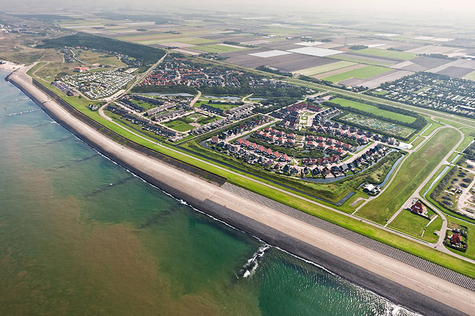
The seawall of Hondsbosch and Petten is a tough, nearly 6 km long dyke that since 1880 excludes the North Sea from the northern part of Holland. The dyke forms a thin and therefore fragile line between sea and land. Partly because the dyke has been significantly raised after the initial construction, it completely shuts of the hinterland from the sea. This problem is most evident in the coastal village of Petten. Here, the sea is nowhere to be seen and therefore the village has gradually turned its back towards the coast. Moreover, the seawall’s resistance strategy towards safety is ultimately unsafe: where the hard, immobile dyke is built on a soft foundation of sand that is subject to erosion and is therefore gradually undermined. Local history with a great number of floods has repeatedly shown that hard constructions in a sandy shore are short-lived.
In this graduation project I have investigated whether a resilient, retreating movement that integrates the existing seawall in a new coastal landscape offers perspectives for both safety against flooding and Petten as a coastal resort.
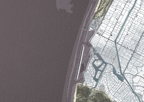
In the lee behind the existing seawall a new resilient coast can be developed. This can be done without giving up the entire medieval polder behind the seawall: 18th century engineering maps show plans for a back-up dyke that today still gives a good indication for the position of a sustainable coastline. First, a sufficiently high water barrier must be made on this location.
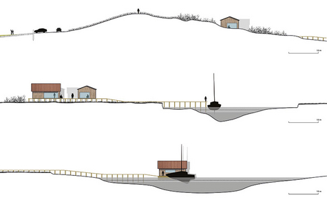
This barrier can be made from clay that is extracted from the seawall, since that will now lose its function as a water barrier. The new dyke will form a new link between the coastal tows of Petten and Camperduin from which the emerging coastal landscape can be observed. By consequently making two holes in the former seawall the ‘invited’ tidal currents ensure that the zone between seawall and water barrier is filled with water and sediment, soon raising this area well above sea level. The former seawall remains present as an elongated island that acts as a breakwater for the hinterland. This island is accessed by a narrow bridge over the route of the Kamperkade, which is the former division between Pettemer and Hargerpolder. To protect the island against erosion and at the same time create a beach, this line is extended as a breakwater representing the part of the Kamperkade that in past centuries was taken by the sea.
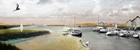
The northern opening in the seawall forms the mouth of a channel that connects the village of Petten to the inland water system of the Schermerboezem. This proves to be an excellent location for a new marina along the Dutch coast. The marina and related properties will form a new district of the village of Petten with a very distinct and dynamic character but well connected to the other districts.
A second breakwater at Petten will ensure a wide beach before the seawall, protecting this part against erosion. Part of the sand form this beach will blow over the seawall, gradually turning it into a dune.
Through these interventions, and especially the resulting natural processes, in the course of two to three decades an attractive, resilient coastal zone will arise. The ‘laid back’ coastline is brought in line with the rest of the Holland coast that now only the island and the village and marina of Petten will protrude from, as ‘outstanding’ features along the Dutch coast.
